
Talk of a “super El Niño” developing in 2026 is gaining momentum, with concerns rising that this climate pattern could bring extreme rainfall, heat, drought and destructive flooding around the world.
The signals appear to be in place: The tropical Pacific is warming along the equator, and computer models point toward extreme conditions by the end of the year.
However, forecasting El Niño is not like predicting next week’s weather. Forecasts for El Niño typically aren’t reliable before late spring – not because scientists don’t understand the system, but because we understand its limits.
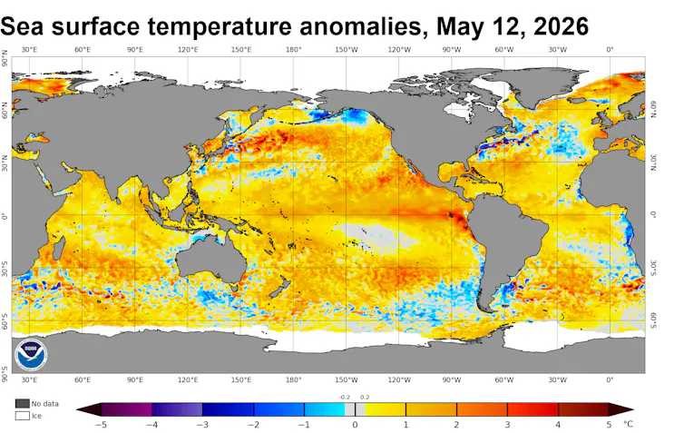
Sea surface temperature data on May 12, 2026, shows warming along the equator west of South America, often a sign that El Niño conditions are developing.
NOAA Coral Reef Watch
As an ocean-atmospheric scientist who studies El Niño, I spend a lot of time thinking about what scientists can forecast confidently – and what remains uncertain. Here’s what we know about the current event, what we still don’t, and why many regions should begin preparing now, even if a strong, or “super,” El Niño never fully materializes.
Why is El Niño hard to forecast in spring
The starting point for any El Niño forecast is the heat stored beneath the surface of the eastern equatorial Pacific Ocean. Computer models use data about those conditions to simulate how ocean temperatures will evolve over the coming months, and how they affect weather patterns around the world.
Right now, an exceptionally large reservoir of warm water sits beneath the surface there. In principle, this ocean heat should be a reliable signal of El Niño developing. In practice, what happens next depends heavily on what the atmosphere does.
The warm reservoir was shaped by a burst of wind activity in early 2026. Normally, the Pacific trade winds blow from east to west along the equator, pushing warm water toward Asia and leaving cooler water near South America. But in April, a pair of cyclones straddling the equator caused the wind direction to reverse. This short-lived reversal triggered a downwelling Kelvin wave – a pulse of energy beneath the ocean surface moving eastward along the equator.
That subsurface pulse has now reached the eastern Pacific, helping fuel intense warming off South America. At the ocean surface, this can resemble the early stages of a strong El Niño.
But there is a catch.
For El Niño to develop fully, the ocean and atmosphere need to lock into a feedback loop: Warmer surface waters weaken the trade winds, triggering more downwelling Kelvin waves that push warm water eastward and reinforce the warming. But that loop doesn’t engage automatically. It requires repeated bursts of eastward winds to sustain the process.
Until that feedback loop takes hold, the ocean-atmosphere system is in an unpredictable phase. It might tip into a super El Niño. It might not.
Spring is precisely when forecasts are most uncertain.