
Right now, cold air high above Antarctica is up to 35ºC warmer than normal. Normally, strong winds and the lack of sun would keep the temperature at around –55°C. But it’s risen sharply to around –20°C.
The sudden heating began in early September and is still taking place. Three separate pulses of heat have each pushed temperatures up by 25ºC or more. Temperatures spiked and fell back and spiked again.
It looks as if an unusual event known as sudden stratospheric warming is taking place – the unexpected warming of the stratosphere, 12 to 40 kilometres above ground.
In the middle of an Antarctic winter, this atmospheric layer is normally exceptionally cold, averaging around –80°C. By the end of September it would be roughly –50ºC. This month, atmospheric waves carrying heat from the surface have pushed up into this layer.
In the Northern Hemisphere, these events are very common, occurring once every two years. But in the south, sudden large-scale warming was long thought to be extremely rare. My research has shown they are more common than expected, if we group the very strong 2002 event with slightly weaker events such as in 2019 and 2024.
Sudden warming may sound ominous. But weather is messy. Many factors play into what happens down where we live.
A drier, warmer spring and summer for southeastern Australia usually follow these warming events. But at present, forecasters are predicting warmer than usual temperatures across Australia alongside a wetter spring in the east.
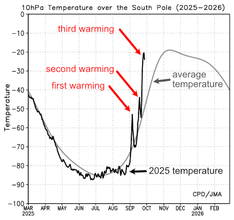
This graph shows the air temperature 30km above the South Pole. The normal seasonal cycle of temperature is in light gray, while the black line shows actual temperatures this year. Stratospheric warming first occurred on 5 September, followed by a second pulse around 14 September and the strongest warming so far peaking on 27 September.
Martin Jucker/Japan Meteorological Agency
What’s happening in the skies over Antarctica?
High above both the Arctic and Antarctic is a large area of rotating winds called the stratospheric polar vortex. By definition, sudden stratospheric warming events affect these two systems.
Over Antarctica, these events are usually detected about 30 kilometres above the Southern Ocean, just to the north of Antarctica’s coastline.
The Antarctic winter runs from March to October. During this period, the continent and the atmosphere above it are dark and very cold, as the sun doesn’t rise until September.
The polar vortex traps intensely cold air and keeps it isolated from the warmer air at lower latitudes. But every now and then, this can change.
Just like the ocean, the atmosphere has waves. What’s happening at present is that large-scale atmospheric waves have spread from the surface up into the stratosphere above Antarctica, bringing heat energy with them. As these waves interact with the strong winds of the vortex, they transfer this heat.
This is only possible during the Antarctic winter,