Greece’s government has just declared a state of emergency on the island of Santorini, as earthquakes shake the island multiple times a day and sometimes only minutes apart.
The “earthquake swarm” is also affecting other nearby islands in the Aegean Sea. It began gradually with numerous very minor (less than magnitude 3) and mostly imperceptible earthquakes in late January. However, at the start of February, the seismic activity intensified as the quakes became larger and more frequent.
So far, several thousand quakes have been recorded in the last two weeks. As many as 30 a day have been above magnitude 4.0 – most of them at less than 10km depth, which is large and shallow enough to be felt by people living on local islands.
These larger earthquakes have resulted in rock falls along the islands’ coastal cliffs, as well as minor damage to vulnerable buildings. The largest earthquake so far was magnitude 5.1 on February 6, which was also felt in the capital city, Athens, as well as in Crete and in parts of Turkey more than 240km away.
Usually a popular tourist destination, Santorini is now virtually empty. Over the past week, some 11,000 holidaymakers and locals have left the island, with many fearing the seismic activity may presage a volcanic eruption.
So how exactly does an “earthquake swarm” happen? And what might happen in the coming days and weeks?
No stranger to earthquakes
This area of the world is no stranger to earthquakes. Greece is one of the most seismically active regions in Europe.
The current seismic activity is located near Anydros, an uninhabited islet about 30km northeast of Santorini. This region lies within the volcanic arc of the “Hellenic subduction zone”, where the African tectonic plate is slowly sliding beneath the Eurasian plate (and specifically the Aegean microplate). The region hosts volcanoes as well as numerous weak zones in the crust – what earth scientists often call “faults”.
Santorini itself is a mostly submerged caldera – a crater formed as a result of volcanic activity over the past 180,000 years, with its last eruption in the 1950s. Earthquakes can be connected to volcanic activity – specifically, the movement of magma beneath the surface.
However, this earthquake sequence is not located beneath Santorini. And local scientists monitoring Santorini have reported no change to indicate the current seismic activity is a forerunner of another Santorini eruption. Instead, the earthquakes appear to align with faults lying between Santorini and the neighbouring island Amorgos.
Nearby faults are known to have produced earthquakes before. For example, in 1956, a 7.8 magnitude earthquake here also produced a damaging tsunami and was soon followed by a magnitude 7.2 aftershock. More than 53 people died as a result of this earthquake and the aftershock and tsunami. Many more were injured.
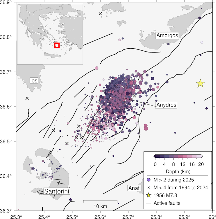
Earthquakes, shown as coloured circles, of the January-February 2025 Anydros swarm, » …